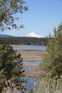
 Mount McLoughlin dominates the northeastern sky over the Upper Rogue. Mount McLoughlin has been known by a number of different names over the years, including Mount Pitt (after the Pit River), Big Butte, M’laiksini Yaina (Klamath Indians), Malsi (Takelma Indians), Mount Shasty (although this name was applied to Mount Shasta to the south by the 1841 Wilkes Expedition), and Snowy Butte. It’s the sixth highest Cascade peak in Oregon but relatively unknown. The Pacific Crest Trail skirts the eastern and northern sides and also accesses the only trail to the summit. On a clear day, the Sky Lakes Wilderness area, Crater Lake, Rogue Valley, and Mount Shasta are visible from the summit. This is the highest peak between Shasta and South Sister. To summit is an 11 mile round-trip hike, that is moderate to difficult, and recommended only during mid to late summer after snow has melted from the trail.
Mount McLoughlin
||Comments Off on Mount McLoughlin